|
 |
| Home |
| About Orkney |
| History |
| Tradition |
| Folklore |
| Placenames |
| Images |
| Downloads |
| About the Site |
| Contact |
| Links |
| Search Site |
| Awards |
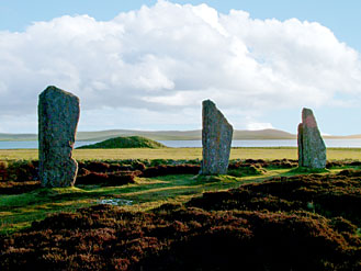
| The Ring of Brodgar, Stenness | |
|
The significance of the landscape Salt Knowe
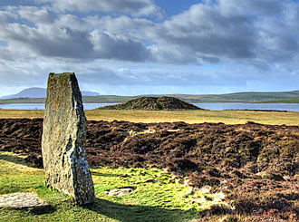
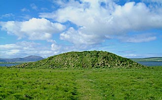
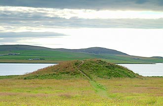
Towering above the low fields flanking the shore of the Stenness loch, the huge man-made mound known as the Salt Knowe is at the end of a track to the south-west of the Brodgar ring. Thought to date from between 2500BC to 1500 BC, the mound is perhaps the most striking landscape feature in the area. Measuring 40 metres (131 feet) by 33 metres (108 feet) and about six metres high (19.6 feet), the mound's position by the salt-water loch is undoubtedly the origin of its name. The sheer size of Salt Knowe, matched only by Maeshowe, had archaeologists thinking it housed a Neolithic chambered cairn. However, a combination of modern research and antiquarian “excavation” has confirmed this is not the case. Scans of the knowe, by Orkney College Geophysics Unit in 2008, using ground-penetrating radar, showed that it appears to be nothing more than a massive mound of earth, with no central structure. This discovery ties in with a letter written to The Orcadian newspaper in 1861 by the antiquarian James Farrer. Farrer, who was responsible for excavating Maeshowe, also had a look at the mounds around the Ring of Brodgar. In his letter he wrote: “Certain it is that no stones of large dimensions are found at any depth in either of the tumuli. In each of them I have made an excavation, and find remains of animal, but no human bones; in each also the bones are chiefly in the upper part of the mound. The workmen have in both instances penetrated the subsoil, to the depth of 22 feet from the top and over an area of nine feet square in the tumulus…” Farrer’s investigation intrigued local archaeologist Nick Card of ORCA, who had long wondered about the significance of the mound. He said: “His findings, or rather lack of them, would seem to support the theory that it is neither a Bronze Age barrow or chambered tomb, as I had suspected, and may be the Orkney equivalent of Silbury Hill. Once again this emphasises the close links between these areas 4,500 years ago. At least one other similar mound has been recognised in Scotland at Dunragit in Dumfriesshire, in association with another Neolithic ritual complex. ”. Silbury Hill, in Wiltshire, is the largest man-made mound in Europe. The latest theory on the monument was that it was a ceremonial mound – something confirmed by the lack of domestic, or indeed ritual, debris in the vicinity. Embedded in the chalk were large "sarsen" stones – similar to those at Stonehenge – which prompted the theory they may represent the souls of the dead. So rather than being a burial chamber, Silbury, it is suggested, was a massive "symbolic mausoleum”. Do we have the same situation at Salt Knowe? Was the mound erected to match the shape and dimensions of the nearby Maeshowe? But instead of being constructed as a "house of the dead", was Salt Knowe a dwelling for the ancestors? |
A Bronze Age burial cist, which is still visible, was cut into the flattened top of the knowe. The 2.6 metre long cist was divided into two parts by a stone partition. It remains possible that this cist was the sole reason for constructing the mound. Records show that nine silver arm-rings were found when Salt Knowe was "investigated" at some point before 1700. These arm-rings dated from the 9th and 10th centuries AD - well into Orkney's "Viking period". Where they were found, however, is not recorded. |